Checking Eldoret Off My 2025 Travel Bucket List
After spending time in Kericho for a staycation earlier this year (those panoramic tea plantation views still linger in my mind), it was only right that Eldoret be next. I’d penciled it into my 2025 travel bucket list, not just as a city to explore, but as a base for venturing further into Kenya’s western highlands, upper north, and even parts of the south. It wasn’t meant to be a city-only trip. The plan was clear: explore more, go further, see what lies beyond the usual.
To be honest, I hadn’t fully made up my mind about the specific day we’d leave. The weather had been wildly unpredictable back home; sunshine one moment, rain the next. But when the day finally came, we got lucky. A spotless morning sky set the tone locally, and surprisingly, that bright sun stuck with us the entire way. Across seven counties, no clouds or rain, but pure sunshine.
Yes, seven counties in one trip: Nyeri, Laikipia, Nyandarua, Nakuru, Baringo, Elgeyo Marakwet, and finally, Uasin Gishu (home to Eldoret city).

NB: For anyone curious, the distance from Nyeri to Eldoret via Kabarnet is 396 km, about 76 km longer than the more common route that touches Timboroa.
Sunrise Departure from Nyeri
We left Nyeri town at around 6:00 am, just before the sun popped up. It’s been a long while since I saw a sunrise quite like this one. The sun appeared from the right side of Mt. Kenya’s peaks, its golden light stretching over the land, setting everything aglow. To the east, you could see mist lying just below the mountain, hovering like a low, floating veil over the land.
We took the Nyahururu route. Between Nairutia and Jikaze, the greenery was striking, a sharp contrast to what I’d seen during my trip to Naivasha via Njabini, all thanks to the recent rains. The Aberdare forest on the Nyeri side stood bold in the morning light.


Also, there was a stunning collection of candelabra trees (Euphorbia ingens) along this stretch. They are cactus-looking trees with a bit of a dangerous reputation in Kikuyu land. Fun fact: if the sap hits your eyes, locals swear the only cure is a rinse with breast milk. I’m not making that up!
First Stops: Nyahururu Town and Subukia Viewpoint
Our first official stop came at Nyahururu Town, and it was just a quick one, to stretch and answer nature’s call. The road up to this point had been kind, with traffic moving smoothly.
Twenty minutes later, we made another stop at Subukia Viewpoint.


This place deserves more attention than it gets. If you’ve never been, let me paint the picture: you’re standing on a ridge, with Subukia town nestled down in the valley, hugged by hills on every side. To the right, the Subukia shrine peeks out from the greenery, while giant greenhouses dot an extensive portion of the land far behind.
Choosing the Scenic Detour Over the Main Highway
Instead of the familiar route from Nyeri to Eldoret (via Nakuru City, Timboroa, and Burnt Forest), we deliberately chose the road less traveled. Our sights were set on Mogotio, Marigat, Kabarnet, and eventually, Iten. I’d spent enough time watching YouTube videos and flipping through Instagram photos of the spots along this route. This time, my eyes needed their own front-row experience.
Arrival in Nakuru City and the Road to Mogotio
We pulled into Nakuru City at around 9:15 am. After a brief pause, we headed out towards Mogotio. A few kilometers outside Nakuru CBD, we passed by Kiamunyi, then Mercy Njeri (a location named after a young student from Kiamunyi Primary School who sadly passed away from a rheumatic illness). Not far ahead was Kabarak University, which may not yet rank in Kenya’s list of “universities with iconic gates,” but it does command its own quiet presence.
Along this road, vast wheat fields opened up on both sides, some sprouting green, others already harvested. It was a welcome shift in scenery, a perfect countryside view.


The stretch to Mogotio didn’t offer much else in terms of landmarks. The drive was mostly smooth, save for a few rough patches under construction. I took pictures of two tortoises casually crossing the road. And here’s something I didn’t know: they hiss when threatened. Along the way, school kids were herding cattle and goats, adding to the typical rural roadside life.
Just across the tarmac is the Mogotio Equator Crossing, once an internet darling. Sadly, the equator monument there now sits neglected and forgotten. Also dotting the roadside are names such as Athinai Secondary School, AIC Morop Girls, Mogotio Girls High School, Lomanira Splendor, and Ravine Glory Hospital.
Mogotio itself is quiet, with scattered settlements. I was lucky to find the area somewhat green, probably still riding the wave of the recent rains. It’s also where you’ll officially enter Baringo County, marked by a modest signpost.


Rolling Into Marigat: Where Mother Nature Starts to Flex
As we got closer to Marigat, something shifted. The green flat lands with patches of shrubs and small trees gave way to grand stretches of hills that seemed to rise from nowhere. The scenery started stretching wide and far. Somewhere along this road, before actually reaching Marigat Town, we spotted Lake Baringo shimmering faintly on the horizon.
As you approach Marigat itself, there’s a sharp turn-off that takes you to Lake Bogoria. You’ll see several resorts and lodges around that junction, a handy tip for anyone who might want to overnight here or make a lake detour.
But we weren’t lake-bound this time. Roughly 2.2 km from Marigat, we turned onto the Kabarnet road. And this next bit? It needs its own chapter.

Climbing Towards Kabarnet: Where the Rift Valley Shows Off
This road is not for the faint of heart or faint of engine. Somewhere along it, there’s a brutally steep climb, so make sure your car is up to the task. But if your engine can take it, your eyes are in for a feast. The higher we went, the more dramatic the landscape became.


The Koriema area marks the start of some of the most photogenic scenery I’ve ever seen in Kenya. Imagine rolling green hills stretching far and wide, occasionally interrupted by steep cliffs or tight curves. The terrain looks like it was arranged by an artist. Strategic viewpoints pop up now and then, tempting you to pull over and just soak it all in.
Tugen Hills Viewpoint: A Showstopper
Hands down, the Tugen Hills Viewpoint was the winner of the day. This place hit different. Picture it: sharp, towering hills stacked closely together, rising like pyramids cloaked in green. If you’re into landscapes that make your jaw drop a bit, this is the place to park and pause.


From here, you also get a distant, delicate view of Lake Baringo. It’s far, but binoculars would do the trick. And right in the middle of it, Ol Kokwe Island stands out with its calm presence. A local shared that the island actually has a polytechnic, a primary school, and a secondary school. I was impressed; schooling with a lake view is something else.
Photos struggle to do this place justice, but we took plenty anyway.
Kabarnet Town and a Glimpse of Political History
After soaking in all those views, we rolled into Kabarnet town. At the Kabarnet-Iten junction, you’ll find the Moi Monument standing tall, an unmistakable welcome into the Baringo County headquarters. Right nearby is the old KANU office, a piece of political history that might go unnoticed if you’re not paying attention.
 Kituro High School


This part of the drive began to feel more urban, but we weren’t done with natural wonders just yet.
The Legendary Kabarnet-Iten Road and the 30 Corners
From Kabarnet, it was mostly a downhill cruise. This stretch of road is famous for its curves. Please make sure to stop at the Kabarnet SS viewpoint, which gives you a clear look at the 30 bends of the Kabarnet-Iten road. Yes, someone counted them. The turns wind tightly as they snake toward the Keiyo River that cuts through the valley in bold, swerving lines.


And then we saw it: the Keiyo Escarpment in full view. High, dramatic, and green, it looked like a barrier separating two worlds.
Chebloch Gorge: Deep, Narrow, and Absolutely Worth It
We finally reached Chebloch Gorge, a narrow crack in the earth carved by the Keiyo River. It’s famous online for the local youth who dive from frightening heights into the water below. Sadly, we didn’t witness any jumping action that day, even though it was a Saturday. No regrets, though; the place still radiated some thrill.


We spent some time here, snapping pictures and just absorbing the view. It was scorching hot, though. Here, Baringo County ends, and Elgeyo Marakwet County begins.
 Kerio escarpment, as viewed from Chebloch gorge


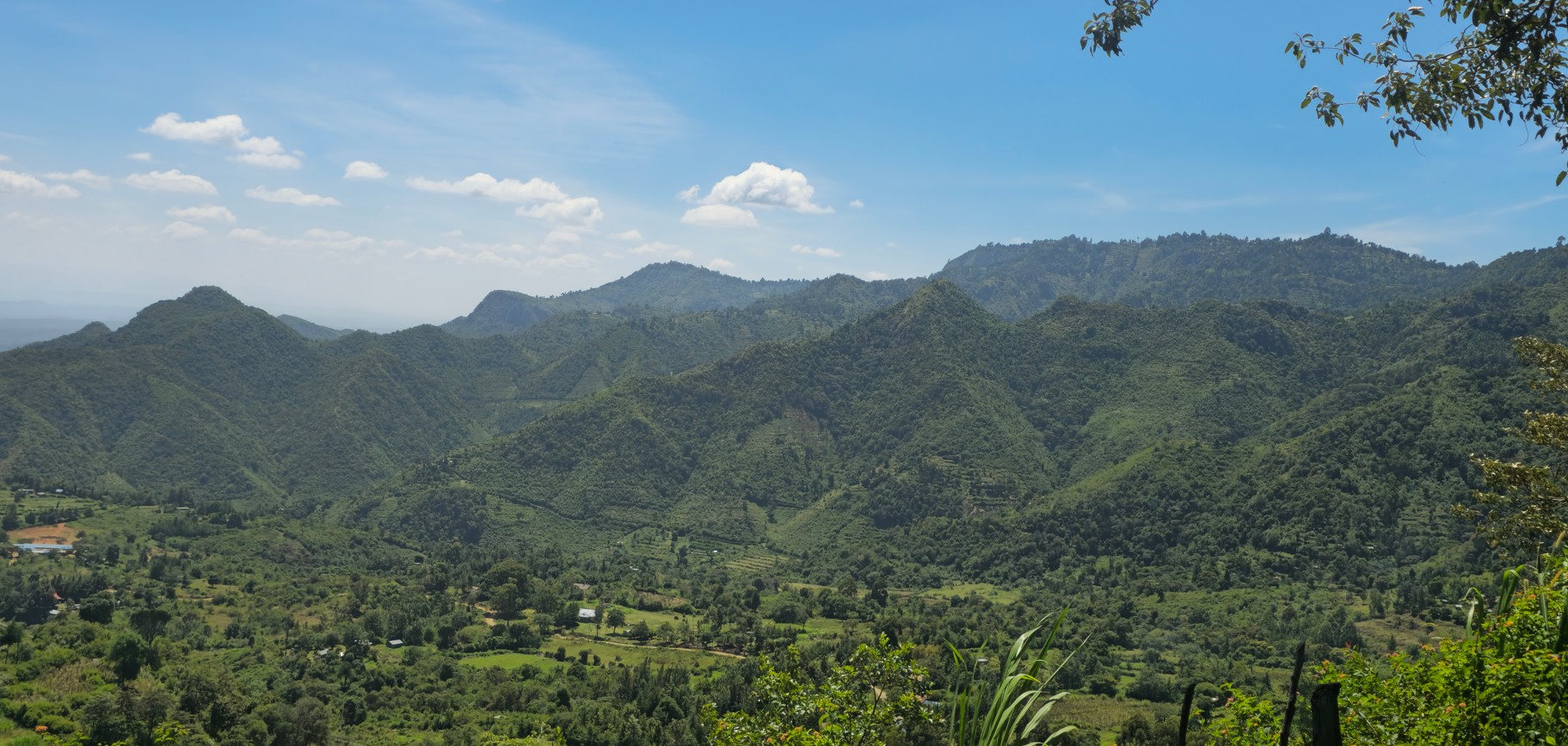
Driving Through Kerio Valley: Magic in Every Kilometer
As we moved deeper into Kerio Valley, I ran out of adjectives. The place is unreal, the kind that steals your attention and holds it hostage. It’s a never-ending roll of green hills, sharp cliffs, and sprawling escarpments.
Every single kilometer had something new to offer. I could try to describe it all, but this is where the camera took over. Some places are too beautiful for words.


Kolol Viewpoint and an Unexpected Waterfall
We continued past Biretwo, and a little further on, at a sharp bend, we reached Kolol Viewpoint, a spot that gets plenty of attention online. From here, you’re treated to a sweeping view of the upper and wider stretch of the Kerio Valley, complemented by escarpments on the right. Remember the Chebloch Gorge we just climbed out of? Kolol is one of the high vantage points offering some of the most stunning views back down into the valley.
 Kerio Valley


Then came a surprise: just a few meters past Kolol, we caught sight of a waterfall cascading from a distant escarpment. What made it even more cinematic was the way the wind carried the falling water sideways, like it was floating in midair. Nature has a way of pulling its magic quietly in the background.


Onward to Tambach and Iten
Next, we reached Tambach, where I caught a peek of the well-known Tambach Teachers College. The buildings sit quietly near the road, surrounded by hilly countryside that would probably distract me at least once a day.


Then came Iten. For many, it’s the land of champions, home to Kenya’s long-distance running legends. While we didn’t stop long, just being there felt like stepping onto hallowed ground.
Rolling Into Eldoret and Wrapping Up at Timba XO
Finally, Eldoret City. This wasn’t my first time here, so no surprises. But it still felt good to be back. We checked in at our B&B and headed straight to Timba XO for a late lunch. Or was it an early supper?
Now, Timba XO is a combo deal: nightclub, restaurant, and VVIP lounge, all under one roof. Inside, the ambience was warm, with vibrant wallpaper murals that would make any design enthusiast pause. The service? Impeccable. We got full attention, right from the menu rundown to food recommendations.

I ordered vegetable rice, which delivered exceptionally in both looks and taste; that’s a 10/10. My partner went for the chicken strips stir fry, and let’s just say I had a satisfied companion at the end of that meal. Price-wise, everything was reasonable, especially for the quality and portions. At night, two rotating beams of light slice into the sky from the rooftop, giving it an almost space-launch feel.
With that said, here are a few shots I captured around Eldoret city the next day.


Final Thoughts on My Nyeri to Eldoret Road Trip
The Nyeri to Eldoret trip turned into one of the most scenic, diverse, and unforgettable journeys I’ve taken in a while. Each county we crossed added something special to the journey: changing landscapes, unexpected wildlife, roadside culture, and even monuments like the Mogotio Equator Crossing and Moi monument.
Nyahururu and Subukia warmed us up with quiet beauty, but it was the raw, breathtaking drama of places like Kerio Valley, Kolol, and Tugen Hills that completely stole the show. The views still play in my head like a looping screensaver. Chebloch Gorge’s silence, broken only by the breeze and the Kerio River far below, had its own kind of thrill. Places like Tambach and Iten reminded me how much heritage and pride are wrapped up in these hills.
Would I recommend this detour-packed route over the usual Timboroa road? A thousand times, yes. If you have the time, curiosity, and a decent set of wheels, take this road and let the Rift Valley show you her full range. You’ll come back with stories, snapshots, and maybe a sunburn, but definitely no regrets.
You won’t regret it.

Ezekiel Maina is the brains behind ContentGenics, where he pairs creativity and strategy to craft B2B and B2C content that real people love to read. He has written for brands like House Digest, iFoundries, Harmony Home Medical, Postaga, and BeamJobs, and covered topics like home improvement, real estate, freelancing, digital marketing, career growth, food & travel, automotive, durable medical equipment (DME), and Cannabis. By day, he’s crafting content, catching up with clients from his home office, lost in a good book, or occasionally chasing nature and greenery in another county. By late evening, he’s typically deep in a documentary rabbit hole on Netflix or YouTube.
Discover more from ContentGenics
Subscribe to get the latest posts sent to your email.
Comments are closed